Tuesday, April 14, 2020

Landforms ------ Lesson 1

Focus QuestionHow are mountains important to people’s lives and how do human activities affect mountain environments?


Content Summary


Landforms are natural features of the Earth. There are different formations on the earth which occur naturally. Some areas are high while others are low. These natural features may be seen on a special type of map known as a relief or physical map. How high the land is above the level of the sea determines the type of landform that is present. Landforms include:


 Mountain:   highlands that rise more than 500 metres above sea level

 Hills:  highland areas that rise between 100 – 499 metres

 Valley:  lowland between two highlands

 Plain:  large areas of flatlands  (Chielfly located on the southern sides of island in Jamaica

 Plateau:    Flat area at the top of a mountain  (flat top mountain)


Examine the diagrams below.
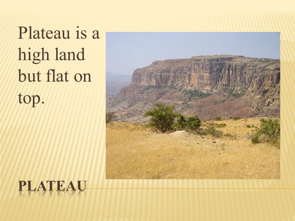
DESERTS, PLAINS AND PLATEAUS. A desert is dry land and has very ...


                                                                                   VALLEY
These Spectacular Valleys in Iran Are Truly Worth Visiting


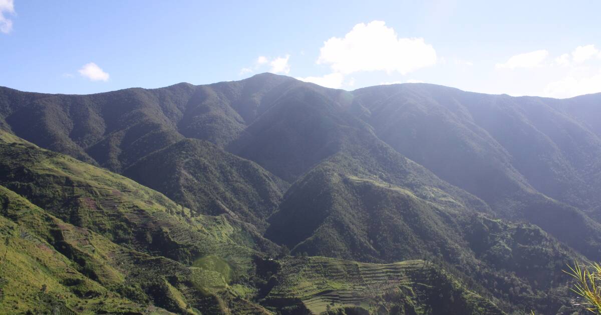
                                                                             MOUNTAIN
Blue and John Crow Mountains - UNESCO World Heritage Centre

                                                                               
                                                                                    PLAIN


Chiayi–Tainan Plain - Wikipedia


                                                                       HILL
File:Silbury Hill 03.jpg - Wikimedia Commons


You may also watch this  slide show to glean additional information.

You may also watch this video clip for more information.


Evaluation
Landforms & Bodies of Water Geography Unit | Social studies ...


1.  2.      Roy was asked by his teacher to read about hills, plateau, mountains, valleys and plains. Under which topic at the Library would he most likely find the information?

(a)    Islands       (b) landforms       (c)  oceans      (d) volcanoes

2.      _________________________________________________________________________________________________________________________________________________________________________________________________________________________________________________________________

3.    3.    Dwight bragged all week about the landform he drew which was a flat top mountain. What did he actually draw?

¡   valley         ¡   mountain         ¡   plateau        ¡   plain         ¡   hill

4.   
    4. Which is an example of a plateau in Jamaica?
(a)    Bull Head Mt.        (b)         Mocho Mt.     (c)      Dry Harbour Mt.  (d)  Rocky Mountains


EXTEND/ELABORATE

Find out the hill or mountain ranges that are close to your  school. Also,

(a)    How the mountains run

(b)   Names of mountains in the East,  central and western parts of the island

(c)    Which is the highest

(d)   Name and identify some of the major plains in Jamaica and where they are located


1(e)   Tom was asked by his teacher to tell which physical feature is located in Trelawny. He chose letter “A” for his answer.
(A)    Blue Mountains   (B) Bull Head Mountain   (c) Cockpit Country   (D) Santa Cruz Mountain

(i)                  Was Tom’s answer correct?  YES / NO

(ii)                Justify your answer. ________________________________________________________

2. (f)   What do most southern parishes have in common?

(a)    Mountainous shorelines  (b) rivers flowing northerly   (c) valleys & Caves  (d) coastal plains

Provide one reason for your answer. ___________________________________________

3.(g)    Which would be on a relief map?

(a)    Manufacturing zones  (b) plains and mountains  (c) population distribution  (d) rainfall distribution

4. (h)    Which mountain is correctly matched with its parish?

A.      Blue Mountains   …. St. Ann

B.      Dolphin Head _____St. Mary

C.      Mocho Mountains  ………Clarendon

D.      Don Figueroa ---------- St. Thomas

5.   (I)   In which parish are there no mountains?

¡      St. Andrew           ¡     Trelawny            ¡     Kingston         ¡   Portland  ¡Westmoreland

6
Open this link to complete the interactive activity on landforms. Drag the mouse to answer the questions.


Monday, April 13, 2020

The Skeleton

The skeleton is the bony framework of the body. It consists of approximately 206 bones.

The diagram below represents the human skeleton.


Pin by Greg Gallaher Jr. on Bones | Skeletal system activities ...


The skeleton has a number of functions.
1. It supports the body
2. It gives the body shape
3. It protects vital organs of the body eg. heart, lungs, brain.
4. It causes movement of locomotion.

Watch this video clip to learn more about the skeleton.

Complete the little quiz at the bottom of the video clip.

Evaluation:
1. Complete the quiz here,.

2. Label the skeleton in this link.

3.  Name the part of the skeleton that protects the following organs:
   (a) the brain
   (b) the heart

4. Your friend, Rob does not believe that the skeleton is all that important. What are your views about Rob's belief?______________________________________________________________________

Provide some points below to share with Rob so he can change his belief.
___________________________________________________________________________________
___________________________________________________________________________________
___________________________________________________________________________________


5. The skeleton is sometimes labelled with the scientific names for some bones.
some examples are:
clavicle - collar bone
sternum- breast bone
patella - knee cap
cranium- skull
femur- leg bone

Now on the diagram below, try to label using both names where applicable.

Skeleton - blank printable | Menselijk lichaam, Menselijk skelet ...

6. Where in the body can you find the:
(a) the largest bone? _________________________
(b) the smallest bone? ________________________

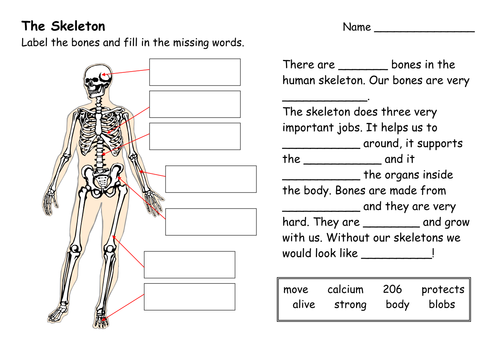
7. The Human Skeleton | Teaching Resources
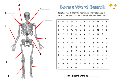
Bones Word Search | Teaching Resources
bones of the human body | My Bones Poster - Elizabeth Richards ...


Click on this link and complete the activity. Drag the mouse to name the parts of the skeleton.


Friday, April 3, 2020

Reflection

Topic: The Cartesian Plane - Reflection

Focus Question: How do I use the Cartesian Plane?

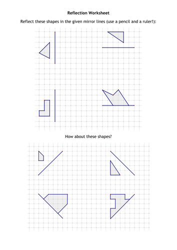
Content: This refers to a transformation that involves a flipping movement of a figure over a line.

Obj.: Perform reflection of a shape or design in a horizontal or vertical line in the first quadrant of the Cartesian Plane.

Engage: Students you would have remembered the following terms from the previous lesson on plotting coordinate points and reading coordinates points. Define the following.

* quadrants
*x-axis
*y-axis
*coordinate points
*point of origin
*ordered pair

Explore: Today we will be looking at reflection.
This refers to a flipping movement of a figure over a line.
Examine the video clip to glean information on reflection.

Explain : Can you now explain what you have learnt from the clip?
You would have learnt that:
(a) the shape was reflected about the mirror line
(b) the position of the shape has changed
(c) each point of the reflected image is the same distance from the mirror line as corresponding point of the  first shape
(d) the shape and size of the shape has not changed.

Extend: You may watch the other video clip below to glean additional information for note taking.

Evaluate: 
1. Complete pages 220 - 221 of your Prime Mathematics For Success Workbook.
2.
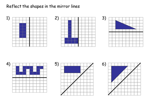
 Reflections | Teaching Resources
3. Reflection Worksheet | Teaching Resources


Thursday, April 2, 2020

The Cartesian Plane


Focus Question: How do I use the Cartesian plane?


Content Summary`

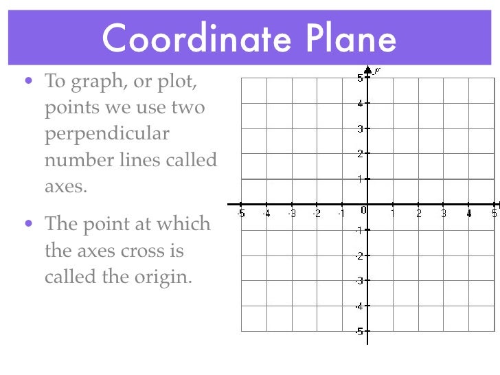
A coordinate plane contains a horizontal number line called the x-axis and a vertical number line called the y-axis. The point where the two axes cross/intersect is called the origin. The number pair (0,0) gives the coordinates of the origin.

To read or plot a point, we use an ordered pair made up of its x-coordinate and y-coordinate. These coordinates measure the distance from the origin.
Examine the link below for additional information.


Specific Obj: By the end of the lesson, students should be able to:

1.      
          1. Explore how a coordinate system identifies location and use the first quadrant of the Cartesian plane to plot points.


ENGAGE:


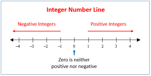
Students you will recall that the number line was done in previous grades. What do you remember about the number line?

Ok let's see what it looks like again.
Integer Number Line (solutions, examples, videos)

EXPLORE:

Now to plot coordinate points, we use two number lines as shown below.
Unit 4 hw 1 - coordinate plane, d&r, midpoint
Now watch this video clip to see how we can plot points. Be sure to take your notes.

EXPLAIN

Now can you explain all you have learnt.

EVALUATE:

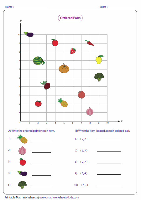
1. Using the diagram below, write the coordinate points of each place.


2. Ordered Pairs and Coordinate Plane Worksheets


3. Grade 4 Geometry Worksheets - free & printable | K5 Learning

4. Do  this interactive game. Its fun!!!!!